Creating geospatial record properties
For a chart item in Analyst's Notebook to appear on a map in i2 Maps, it must contain at least one i2 Analyze record that has at least one geospatial property. Records from the Information Store or external sources might already have geospatial properties, or you can add them manually.
Note: By default, Analyst's Notebook adds chart items that meet its criteria to the map in the i2 Maps window automatically. You can change this setting in the i2 Maps window.
Viewing geospatial properties
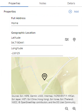
When i2 Analyze records contain data in geospatial properties, Analyst's Notebook displays their geographic coordinates and map locations in the Properties tab of the Record Inspector.

The Record Inspector always displays geospatial property values as a latitude and longitude pair. However, when you add or edit a geospatial property, you can enter the values in a different coordinate system and let Analyst's Notebook convert them.
Adding and editing geospatial properties
For a record that doesn't already have one, you can add a geospatial property of a schema type or a custom type through the Record Inspector in the usual way.
To edit an existing geospatial property value or to add a new one, you have three options:
Enter values for the Latitude and Longitude fields directly in the Record Inspector.
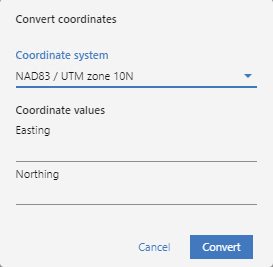
Click Convert from another coordinate system to open the Convert coordinates dialog:

In this dialog, you can choose a different coordinate system and enter appropriate coordinate values. When you click Convert, Analyst's Notebook supplies converted values to the Latitude and Longitude fields.
Click Set location from a map to open a map from the Record Inspector, and then click a location to set the property.
